There is a moment, somewhere above Namche Bazaar at roughly 3,500 meters, when the helicopter banks left and Everest slides into the forward window. The trek to Everest Base Camp takes 12 days, covers 105 kilometers, and demands everything from your knees, lungs, and patience.
Not the distant hazy pyramid you've seen in photographs. The actual mountain; north face, southwest pillar, summit plume trailing sideways in the jet stream, filling a significant portion of the sky.
This is the moment the Everest Base Camp helicopter tour earns everything it charges.
You're Off the Ground Before Kathmandu Wakes Up
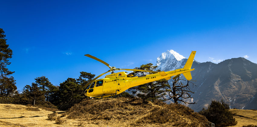
By 7 AM, the Eurocopter AS350 B3e (Airbus H125) is lifting off from Tribhuvan International Airport. This particular aircraft is worth knowing about. The machine, nicknamed the “squirrel,” is the same high-altitude rescue helicopter used on Everest expeditions. It is specifically designed to operate in extremely thin air above 5,000 meters, built for it from the engineering up.
Five window seats. Everyone gets an unobstructed view.
Below, Kathmandu's flat valley gives way quickly to the corrugated ridgelines of the Middle Hills. Terraced farms on impossible slopes. Villages that look hand-placed on cliffsides. Then, in stages, the scale shifts. The hills grow into peaks. The peaks grow into something else entirely.
Lukla From Above
Forty-five minutes into the flight, the helicopter touches down at Lukla for refuelling. At 2,845 meters, the temperature drop is immediate and physical.
Tenzing-Hillary Airport at Lukla sits at an altitude of 2,845 meters with a runway of just 527 meters that ends at a steep mountain drop-off. From a helicopter parked beside it, the runway looks exactly as insane as it sounds. Fixed-wing pilots flying here are required to complete special training. The uphill slope, the cliff at one end, the mountain wall at the other.
Most trekkers who pass through Lukla see it from the ground. Seeing it from a hover altitude is a different category of information.
Khumbu Opens Up
Above Lukla, the Dudh Kosi gorge unfolds. Riverside villages appear and disappear. Namche Bazaar, the high-altitude trading hub at 3,440 meters, ringed by the peaks of Kongde, Thamserku, and Ama Dablam, provides an amphitheatre experience.
The entire sweep of the upper Everest region is laid out like a map from this altitude, with the full scale of the Khumbu Glacier stretching beneath, the iconic ridgelines of the world's highest peaks arranged in sequence.
Then there is the Khumbu Icefall. From Base Camp on the ground, climbers see its lower section, a chaotic compression of ice blocks and crevasses, shifting several meters daily. From helicopter altitude, the full geometry of the icefall is visible and a frozen river sits two kilometres long, pouring itself down the mountain's south face in slow-motion collapse.
This view is, for many passengers, the image they most struggle to explain afterwards.
The Shuttle Moment: Physics Becomes Personal
Approaching Gorakshep at 5,140 meters, the pilot makes an announcement.
With a full complement of five passengers, the weight-to-altitude equation doesn't allow everyone to reach Kala Patthar in a single flight. The helicopter can only safely carry 250 kilograms at extreme altitude, so a shuttle operation runs from Pheriche, taking two to three passengers at a time to the 5,545-meter landing point.
The wait, for those who go second, lasts approximately twenty minutes. From the ground at Gorakshep, looking up toward Kala Patthar with Everest's summit visible overhead, those twenty minutes are not wasted.
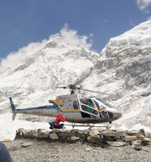
The landing itself is brief. Around ten to fifteen minutes on the ground. The air at 5,545 meters contains roughly half the oxygen of sea level. Breaths feel deliberately drawn, as if the body has only just remembered how. The cold arrives through whatever layers you've worn. And Everest, specifically the part of Everest that Base Camp cannot actually see, because the West Shoulder blocks the summit from ground level—is directly and completely in front of you.
This is the view Kala Patthar is famous for: an unobstructed 360-degree perspective of the summit pyramid and the surrounding amphitheatre of giants: Nuptse, Lhotse, Pumori, and Changtse all visible simultaneously.
Photographs are shot quickly. The altitude makes deliberate movement important. Then the helicopter returns, and the shuttle reverses.
Breakfast at the World Record Hotel
The descent to Syangboche takes minutes. Hotel Everest View sits at 3,880 meters, a Guinness World Record holder for the highest-altitude hotel on Earth.
Imagine the terrace breakfast here, surrounded by Ama Dablam on one side and the Everest-Lhotse massif on the other. This is a fixed stop on the tour that many passengers describe as the emotional centrepiece of the day. The scale of the morning becomes real over tea. The altitude is still high enough that the air tastes clean and metallic. The mountains are close enough that clouds occasionally drift between your breakfast and the peaks.
Nepal's Helicopter Rules in 2026: The Story Behind the Tour
In December 2024, the Khumbu Pasang Lhamu Rural Municipality and Sagarmatha National Park authorities made an announcement that sent Nepal's tourism industry into emergency sessions: starting January 1, 2025, all commercial helicopter flights beyond Lukla would be completely banned, citing disruption to the fragile alpine ecosystem, noise pollution affecting both wildlife and trekkers, and economic disparity concerns.
The EBC helicopter tour is marketed as the “no-trekking option,” but that framing undersells it. It is genuinely ideal for people with physical limitations, time constraints, or those who want a different kind of Himalayan encounter. But it's also for serious photographers who want aerial shots of the Khumbu Icefall. For people celebrating milestones, birthdays, anniversaries, proposals—at 5,500 meters.
The net result for travellers in 2026 was that the tour is operational, regulated, and backed by a framework that takes the Everest region's fragile ecosystem genuinely seriously.
The Route Back, and What It Does to You
From Syangboche, the helicopter traces its path southwest—Namche Bazaar visible below, the Dudh Kosi gorge, then the broadening Middle Hills, then the valley flattening back toward Kathmandu. The whole return leg takes under an hour.
Thyangboche Monastery sits on a ridge below Ama Dablam, and many routes pass over or stop briefly here, with colourful prayer flags a distinct contrast against the rock and ice that has defined the last few hours.
By late morning, Kathmandu is visible. By midday, most passengers are back at their hotels, downloading photographs, and trying to explain to anyone who will listen what it is about Kala Patthar at 5,545 meters that makes the world look genuinely different from up there.
Plan It Right
EncountersNepal's group joining tours depart daily during peak seasons (March-April and October-November), with group prices from USD 1,350 per person. Private charters run USD 9,000 for up to five passengers. The helicopter is a 5-seater AS350 B3e with emergency oxygen on board, and the full tour runs four hours from Kathmandu to Kathmandu.
Best months for clear visibility: October and November (post-monsoon, dry air, excellent mountain definition) and March-April (wildflowers below, stable morning windows above). The tour operates year-round except June through mid-September.
Bring layers. Bring a camera with a fully charged battery, as cold air drains batteries faster than you expect at altitude. And bring the specific kind of attention reserved for things you'll remember for the rest of your life.
Everest isn't going anywhere. But the clear morning window closes fast.